

Sea Level Rise Projections for South West Victoria 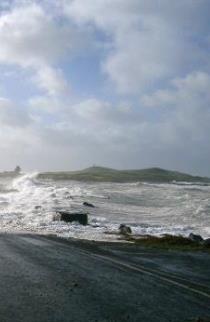
Monitoring of sea levels at a global scale has been conducted since 1870. Since the 1900s the sea had been rising at around 1.7 millimetres annually. However, since 1993, records are showing that this annual rise has climbed to 3.1 millimetres a year and is largely attributable to recent increases in ocean warming, expansion and the melting of land-based ice. Since 1993, Victoria’s sea level rise has been similar to global averages of 3 mm per year.
Sea levels around Australia and indeed Victoria, are not rising equally due to factors such as prevailing winds and changes to ocean currents. For example, monitoring stations at Lorne and Stony Point in Victoria have recorded rises of 2.8 millimetres per year and 2.4 millimetres per year respectively since 1991.
Sea level today is approximately 225 mm higher than in 1880.
In the future, sea level will continue to rise.
By 2030 the projected sea level rise for studied locations is 0.08 to 0.18 m above the 1986–2005 level.
By 2070, sea level is projected to rise 0.20 to 0.46 m at studied locations under lower emissions and 0.25 to 0.56 m under high emissions.
However, depending on how much the Antarctic ice sheet melts, these levels may be higher.
Height of extreme sea level events and storm surges will also increase.
The ocean will get warmer and more acidic. Sea surface temperature is projected to increase in the range of 1.1 to 2.3°C by 2070 under high emissions. The sea will also become more acidic, with acidification proportional to emissions growth.
